Skip to Main Content

GROUNDWATER FAQs

Winter, T.C., Harvey, J.W., Franke, O.L., and Alley, W.M., 1998, Ground Water and Surface Water, A Single Resource: U.S. Geological Survey Circular 1139, 79 p.

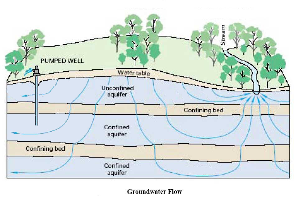
Rates of groundwater movement are extremely variable depending on the size of sediment grains through which the groundwater is moving, the topography, and whether or not any wells are withdrawing water in the area.

In locations where wells are actively removing water from the ground, the rate of groundwater movement will be increased because of the withdrawals. The increase in groundwater movement due to well water withdrawal can occur in both vertical and horizontal directions. Groundwater movement, particularly in confined aquifers, can be quite slow. Using the water level information from numerous wells in the region, pumping tests, and information on the physical nature of the sediments which make up the aquifers, a groundwater model was developed for the area. This model indicated that water entering the DMCF and moving downward into the aquifers would take 15 to 25 years to reach homeowners wells in West View Shores (WVS), Bay View Estates (BVE), and Sunset Pointe, as well as the homes along Pond Neck Road adjacent to the DMCF.

The US Geological Survey (USGS) Pearce Creek report summarized that groundwater in the Pearce Creek area moves from relatively higher elevations to lower elevations. In a general sense, groundwater moves from the DMCF downward into the water table aquifer (Matawan and Magothy Aquifers) and subsequently expanding in all directions, outward toward lower elevation areas such as Pearce Creek Lake and the Elk River. The deeper Upper Patapsco Aquifer is partially confined by an intervening clayey sediment layer, which restricts water movement from the water table aquifer to this deeper aquifer. However, near the southwestern side of the DMCF, this confining clay layer is thin or absent allowing water to move into the Upper Patapsco Aquifer. Because many homeowner wells are withdrawing water from the Upper Patapsco Aquifer the rate of downward movement of groundwater is increased.

Fine-grained sediments on the bottom of the Chesapeake Bay, including the dredged shipping channels, contain a number of naturally occurring chemical constituents along with those introduced to the environment by the activities of humans. As long as these sediments remain in place they are in a reducing environment (i.e. low oxygen concentrations) and nearly all of the chemicals are bound to the sediments and rendered biologically unavailable. These chemicals include iron, sulfur, manganese, arsenic and similar trace metals. Once the sediments are dredged and placed in the DMCF, the introduction of oxygenated rain water, which is also generally acidic, causes geological and chemical changes to take place over time. These changes result in the release and movement of many of these chemicals as well as further acidifying the water in the sediments. Due to the downward and outward movement of the groundwater from the DMCF, these released and mobilized chemicals enter first the water table aquifer and in the area of the thin or missing confining layer, the deeper Patapsco Aquifer. The USGS Pearce Creek Report documented the extent and depths where groundwater quality was degraded as a result of these processes, which affect the geology and the chemicals within them.

The liner was completed in spring 2017. The liner was placed on top of the existing sediments within the Pearce Creek DMCF. Installation of the liner isolated the sediments presently in the facility from further introduction of rainwater and surface water. Sediments and water placed above the liner will not be able to enter the groundwater system. This will reduce the rate of movement of groundwater, both horizontally and vertically, and will reduce the future movement of chemicals in the sediments and groundwater below the liner.

CENAP is currently monitoring groundwater in the vicinity of the DMCF using 37 monitoring wells (19 are pre-existing) under an MDE-approved groundwater monitoring plan. Groundwater samples are collected and analyzed for specific conductance, pH, temperature, oxidation-reduction potential, turbidity, and dissolved oxygen. Samples will also be tested for Total Metals (Aluminum, Arsenic, Beryllium, Cadmium, Calcium, Iron, Lead, Magnesium, Manganese, Nickel, Potassium, Sodium, and Zinc), General Chemistry Parameters (Alkalinity, Total Dissolved Solids, Total Suspended Solids, Fluoride, Chloride, Bromide, Sulfate, Nitrogen (nitrite and nitrate), Nitrogen (nitrate), and Nitrogen (nitrite)), and Radiologic Parameters (Gross Alpha and Gross Beta). Lastly, the groundwater monitoring efforts include five (5) piezometers, which are used to measure the pressure of groundwater.

Groundwater withdrawal via wells increases the movement of groundwater toward the well or wells. Thus, discontinuing withdrawal of water from homeowner's wells will slow the overall movement of groundwater. Movement will still take place as the groundwater travels from areas with higher elevations to locations at lower elevations.
Except for the effect of discontinuing groundwater withdrawals via homeowner's wells, the installation of the water supply line from Cecilton will have no effect on groundwater movement in the vicinity of Pearce Creek DMCF.
Groundwater occurs in the spaces between sediment grains in the ground. Generally speaking, where the sediment grains are coarser (i.e. sands and sands mixed with gravels), water can move freely because there are many pathways between the individual sediment grains. By comparison, fine sediment grains such as silts and clays will impede the free flow of water because there is less space between the grains causing a restriction in the overall movement of water.In many areas of the Eastern Shore, the sediments in the ground consist of alternating layers that are either coarser sands or composed of silts and clays.
An aquifer is one of the coarser grained (sands and sands with gravel) layers that is suitable for supplying a sufficient flow of water to a well.
A confining layer, sometimes called an aquitard, is a layer of sediment that consists of finer grained silts and clays that restricts the movement of water both horizontally and vertically under the ground.
A confined aquifer is a coarser grained sediment layer (sands or sands with gravel) that functions as an aquifer and is separated from overlying or underlying coarse layers by a layer, or layers, of finer grained sediment (silts or clays). The finer grained sediment layer acts to "confine" or segregate the aquifer from the vertical movement of water from higher or lower aquifers. How effectively the aquifer is confined is dependent on: (1) the thickness of the finer grained layer or layers, (2) the horizontal extent of the finer grained layer(s), and (3) the ability of the finer grained layers to impede the movement of water. Generally speaking, the finer the sediment grains and the thicker and wider the confining layer, the more effective the layer is at impeding the movement of groundwater.
The water table is the uppermost aquifer that is in direct contact with the soil surface through precipitation that seeps into the ground. Since the water table aquifer is close to the soil surface and readily resupplied with water from precipitation it is most susceptible to contamination from activities that occur on the land. These activities can include the application of pesticides and herbicides, seepage from landfills, seepage from septic fields, or spills of chemicals on the land, among others.
In general, precipitation enters the soil at the surface, entering the ground in an area known as a recharge zone, and seeps between the sediment grains. The water enters the water table and moves downward through the underlying sediments due to gravity. Absent other factors, groundwater in the water table will continue to move downward to areas of lower elevation, and slowly discharge into nearby streams or continue a downward movement into deeper sediments.
Well drillers attempt to drill into a layer that is sandier and sufficiently thick to supply water to a household and "screen" the well in that sandier sediment layer. The well casing is solid above and below that screened section and does not allow water to enter the well except from the screened section. A pump inserted into the well pumps the water to the surface.
A wide variety of chemicals can be present in groundwater. The types and quantities are greatly influenced by the chemical constituents of the sediments through which the groundwater is moving and, particularly for the water table, the chemical nature of the precipitation and/or constituents applied to the land surface. Absent the chemical constituents supplied from human activities or precipitation, slow chemical changes in the geology naturally occur in the subsurface as the water moves through the sediments.
Contaminants entering the ground from human activities and sources, such as chemical or industrial spills, fertilizer and pesticide application, and homeowner septic fields, can reach the groundwater. The water table is most likely to be affected by these sources because it is in direct connection with the surface of the land. Deeper confined aquifers have a smaller chance of being impacted by activities on the land surface, unless the confining layers permit some water movement downward into the confined aquifer. Comparatively, naturally-occurring chemical constituents of the sediments that make up the aquifer (both confined aquifers and the water table aquifer) can contain non-potable water without the influence of human activities and sources. For example, some aquifers in certain areas on the Eastern Shore contain non-potable water due to the natural presence of arsenic, high levels of Total Dissolved Solids (TDS), high sulfur concentrations or high levels of naturally occurring salt in the sediments. Additionally, in some areas of the Eastern Shore, most notably Kent Island and Ocean City, wells have pumped enough water from confined aquifers that salt water from the Bay or the Ocean is entering the aquifers, making the groundwater non-potable.
Back to Top